


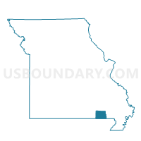
Doniphan P1, Ripley County, Missouri
About
Outline

Summary
| Unique Area Identifier | 609559 |
| Name | Doniphan P1 |
| County | Ripley County |
| State | Missouri |
| Area (square miles) | 60.38 |
| Land Area (square miles) | 59.77 |
| Water Area (square miles) | 0.61 |
| % of Land Area | 98.99 |
| % of Water Area | 1.01 |
| Latitude of the Internal Point | 36.63499160 |
| Longtitude of the Internal Point | -90.80237010 |
Maps


Graphs
Select a template below for downloading or customizing gragh for Doniphan P1, Ripley County, Missouri


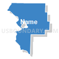

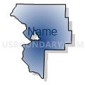

Neighbors
Neighoring Voting District (by Name) Neighboring Voting District on the Map
- Doniphan P2, Ripley County, MO
- Doniphan West Voting District, Ripley County, MO
- Flatwoods/Johnson P2, Ripley County, MO
- Harris Voting District, Ripley County, MO
- Jordan/Johnson P1, Ripley County, MO
- Poynor & Current River Voting District, Ripley County, MO
- Shirley & Kelly Voting District, Ripley County, MO
- Varner Voting District, Ripley County, MO
Top 10 Neighboring County Subdivision (by Population) Neighboring County Subdivision on the Map
- Doniphan township, Ripley County, MO (5,656)
- Jordan township, Ripley County, MO (1,026)
- Harris township, Ripley County, MO (744)
- Shirley township, Ripley County, MO (721)
- West Doniphan township, Ripley County, MO (681)
- Varner township, Ripley County, MO (657)
- Flatwoods township, Ripley County, MO (650)
- Johnson township, Ripley County, MO (549)
- Current River township, Ripley County, MO (216)
- Kelley township, Ripley County, MO (51)
Top 10 Neighboring Place (by Population) Neighboring Place on the Map
Top 10 Neighboring Elementary School District (by Population) Neighboring Elementary School District on the Map
Top 10 Neighboring Unified School District (by Population) Neighboring Unified School District on the Map
Top 10 Neighboring State Legislative District Lower Chamber (by Population) Neighboring State Legislative District Lower Chamber on the Map
Top 10 Neighboring State Legislative District Upper Chamber (by Population) Neighboring State Legislative District Upper Chamber on the Map
Top 10 Neighboring 111th Congressional District (by Population) Neighboring 111th Congressional District on the Map
Top 10 Neighboring Census Tract (by Population) Neighboring Census Tract on the Map
- Census Tract 8703, Ripley County, MO (4,329)
- Census Tract 8701, Ripley County, MO (4,291)
- Census Tract 8702, Ripley County, MO (2,958)
- Census Tract 8704, Ripley County, MO (2,522)